Maharashtra – State’s in depth – Important Facts 24/05/2019 – Posted in: STATE SERIES – Tags: general information, Maharashtra
MAHARASHTRA
Introduction
Maharashtra was formed in 1960 when the Marathi and Gujarati linguistic areas of the former Bombay state were separated. Bombay (Mumbai) city is the capital of the state.
The modern state of Maharashtra is bordered by the Arabian Sea to the West, Gujrat and the Union Territory of Dadara Nagar haveli to the North West,Madhya Pradesh to the North & North East, Chhattisgarh to the East, Karnataka to the South, Andhra Pradesh to the South East and Goa to the South West.
Predominantly consisting of two major relief divisions, namely the Deccan Tableland and Konkan (coastal) strip, Maharashtra covers an area of 307,713 km2.
The Gateway to India— that’s Maharashtra with Mumbai- one of the finest ports of the world.
| Capital | Mumbai |
| Number of Districts | 35 |
| Date of Formation | May 01, 1960 |
| State Animal | Indian Giant Squirrel |
| State Dance | Lavani |
| State Bordering | Gujarat, Madhya Pradesh, Chhattisgarh, Karnataka, Telangana, Goa, UT of Dadar and Nagar Haveli |
| Agriculture |
|
| Language | Ahirani, Malvanin, Varhadi, Konkani, |
| Tribes | Pardhi, Kond, Gond, Bhil, Andh, Barda, Bavacha, Bhattra, Bhunjia, Binjhwar, Dhanwar, Dhodia |
| Institutions |
|
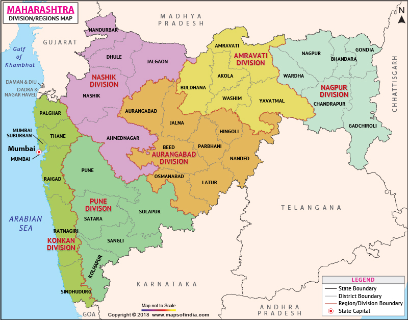
Five Divisions
- Aurangabad Division (Marathwada) Aurangabad, Beed, Hingoli, Jalna, Latur, Nanded, Osmanabad and Parbhani,
- Konkan Division: Mumbai City, Mumbai Suburban, Raigad, Ratnagiri, Sindhudurg and Thane
- Nashik Division: Ahmednagar, Dhule, Jalgaon, Nandurbar and Nashik
- Nagpur Division: Bhandara, Chandrapur, Gadchiroli, Gondiya, Nagpur and Wardha,
- Pune Division: Kolhapur, Pune, Sangli, Satara and Solapur
Geographical feature
The Western Ghats form the source of several major rivers of Maharashtra, notable among them being Godavari and the Krishna. The rivers, along with their tributaries, flow eastwards into the Bay of Bengal, irrigating most of central and eastern Maharashtra. The Ghats are also the source of numerous small rivers, which flow westwards into the Arabian Sea.
The Sahyadri Range is the defining geographical feature of Maharashtra. Rising on an average to an elevation of 1000m, it has Konkan on the west. Eastwards, the topography goes through a transitional area known as Malwa to the plateau level. The Konkan, lying between the Arabian Sea and the Sahyadri Range is narrow coastal lowland, barely 50 km wide. Though mostly below 200 m, it is far from being a plain country. Highly dissected and broken, the Konkan alternates between narrow valleys and low laterite plateaux.
The Satpuras, hills along the northern border, and the Bhamragad-Chiroli-Gaikhuri Ranges on the eastern border form physical barriers preventing easy movement, and also act as natural limits to the state.
This topography of the state is the outcome of its geological structure. The state area, barring the extreme eastern Vidarbha region, parts of Kolhapur and Sindhudurg, is practically co-terminous with the Deccan Traps.
Natural Resources
Apart from mainly occurring rock Basalt; other rocks like- Laterites are found in the coastal humid and tropical region.
Maharashtra is rich in in ore deposits. Granite, Granite gneiss, Quartzite, Conglomerates are found in the basement regions of Konkan rivers. Nanded is another region where pink Granites are found. Kamti of Nagpur region is famous for coal.
Water is the most unevenly distributed natural resource. A large number of villages lack drinking water, especially during the summer months, even in the wet Konkan. Barely 11% of the net sown area is irrigated. The granitic-gneissic terrain in the eastern hilly area of Vidarbha accounts for all tank irrigation. Tube-wells in the Tapi-Purna alluvium and shallow wells in the coastal sands are the other main sources of water. Special wells are being made by the Government for the villages lacking water.
The Chandrapur, Gadchiroli, Bhandara and Nagpur Districts form the main mineral belt, with coal and manganese as the major minerals and iron ore and limestone as potential wealth.
Wildlife
Maharashtra is home to several national parks. Project Tiger, the Government of India initiative to preserve and increase the tiger population, has 4 major areas of concentration in the state namely Tadoba-Andhari, Melghat, Sahyadri and Pench. The Bor Wildlife Sanctuary of Wardha in Eastern Vidharbha was also declared a Special Tiger Zone by the government in 2012.
A large percentage of Maharashtra’s forests and wildlife lie along the western Ghats or western Maharashtra and eastern Vidarbha.
The Gondia region in Vidarbha is home to two important parks: The Navegaon National Park,the nestling ground of of birds, deer and leopards, as well as the Nagzira Wildlife Sanctuary with an assortment of wildlife. The Sanjay Gandhi aka Borivali National Park in Mumbai enjoys the stature of being the world’s largest national park within city limits. Sangli district, for its part, houses the Chandoli National Park, even as the Prachitgad fort and Chandoli dam are in the vicinity.Sagareshwar wildlife sanctuary, a man made sanctuary situated 30 kms from Sangli, contain ancient temples of Lord Shiva, apart from the Jain Temple of Parshwanath. For its part, the Maldhok Sanctuary in Solapur-Ahmednagar district is home to the Great Indian Bustard. The Bhimashankar wildlife Sanctuary situated in the western Ghats is famous for the Malabar Giant squirrel.
Hill Stations
The Sahyadris hold several beautiful hill stations in their lap, which are cool, beautiful and refreshingly serene. Best of all, they are usually near a city. These include Matheran, Lonavala, Khandala, Mahabaleshwar, Panchagani, Bhandardara, Malshej Ghat, Amboli, Chikhaldara Panhala, Panchgani, Sawantwadi, Toranmal, and Jawahar.
True Spirit of God
The Bhakti movement—a medieval movement spread all over the country between the 13th and 17th centuries—that emphasized the true nature of God—as a democratic and loving entity who valued simplicity and heart-felt devotion over ritual and superstition, found resonance in the soil of Maharashtra as well. The roll-call of honour includes saint poets like Dnyaneshwar, Namdev, Tukaram and Chokhamela, apart from several saints from the so-called lower stratas of society who have contributed richly to music, art and literature. The Warkari movement that every year in the month of June-July sees a plethora of farmers and myriad believers in Vitthoba (an avatar of Lord Vishnu) converge to Pandharpur in an annual pilgrimage, which begins with accompanying the palkhis of the late saints from their place of Samadhi/enlightenment. The Warkaris reach Pandharpur on the auspicious day of Ashadhi Ekadashi, chanting the name of God—and the saints. Propogating the values of non-violence, charity, austerity and vegetarianism, the Warkaris are an enduring symbol of tolerance in a chaotic world—even today. Several tourists from the world over participate in the pilgrimage, and come away, moved beyond words with the sheer force of conviction that unites men across all barriers.
Festivals of Maharashtra
Maharashtra is the canter of many religious and cultural traditions. In Maharashtrian villages, life revolves around fairs and festivals.
Each festival comes with its own colors and Cuisine. People do up their houses and surroundings and there is an air of celebration. The festival time is surely a must visit time in India.While the most hugely visible festival maybe the Ganesh Chaturthi, due to the large processions and the colourful images of Lord Ganesha, there are many festivals celebrated with as much enthusiasm and spirit.
Each festival signals the passing of old and beginning of new, and this in most cases is signifies by the victory of good over evil. Each festival has a significance and its mark is always felt in the daily lives of the people in India, specially in rural India.
Each festival comes with its own colors and Cuisine. People do up their houses and surroundings and there is an air of celebration. The festival time is surely a must visit time in India.While the most hugely visible festival maybe the Ganesh Chaturthi, due to the large processions and the colourful images of Lord Ganesha, there are many festivals celebrated with as much enthusiasm and spirit.
Costumes Of Maharashtra
Maharashtra is the Marathi speaking region of India , which lies to the south of Gujrat. The state covers a large area ,and has diversity in the way of living. More than 85% people follow the Hindu Religion. therefore the basic costume of Maharashtra is similar to the costumes of Hindus in other states. The traditional Men’s costume is ‘SADARA’ as an upper garment and ‘DHOTI’ as the lower garment. The traditional costume for women is a ‘NINE YARD SARI’ called ‘LUGADE’ ,wrapped around the body in a very typical way, which is a speciality of Maharashtra and not seen in northern states. This LUGADE is worn with a short length bodice called ‘POLKA/CHOLI’, made or sewn in a characteristic style.
The costumes differ in style according to the different communities living in the state. The main communities can be listed as follows,as far as the costumes are concerned.
- Brahmin
- Maratha – Elite class farmers.
- Farmers – Middle class and lower class.
- Fishermen/Koli.
- Different Nomads.
Regions of Maharashtra
Vidarbha
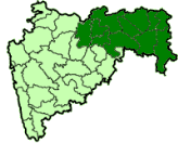
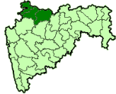
Maharashtra has on its eastern part, the region which is known as Vidarbha and comprises of divisions of Amravati and Nagpur. Previously, this was known as Berar and composed 31.6% of area in the state and shares 21.3% of population. The borders of this region are having Madhya Pradesh towards its north, Chhattisgarh in the eastern side, south is covered by Andhra Pradesh, while the west is having Khandesh and Marathwada regions of the state. Vidarbha is somewhat located towards central India, with its share of rich history and cultural background, bit different from other areas of Maharashtra. In Vidarbha, Nagpur is the biggest city, Amravati being the second biggest, while the city of Akola ranks third and thereafter are the cities of Yavatmal, Chandrapur, Wardha, Bhandara and the city of Gondia. Much of the vernacular dialect is Vahardi and Marathi, the former being one of the dialects in Marathi.
There are 10 seats from region of Vidarbha for Lok sabha representation. The district of Nagpur, which is having the densest population, has 2 seats as the constituency has been divided into the zones of Ramtek and Nagpur, while such districts as Gadchiroli and Chimur are clubbed to make one single constituency, due to the lesser population.
Marathwada
With the Marathwada being one of the five Maharashtra regions, it has the division of Aurangabad. Origin of the name of this region lies in the term Mara-hatti-vada, which is the meaning of one of the communities in Maratha. Aurangabad is the city which is also the headquarters of this region, this name having been derived from Aurangzeb, who had his rule in this region for a small period
Plenty of monuments belonging to the communities of Sikh, Muslim, Hindus and Jains are found in Marathwada. Some of the important ones are Jyotirlingas in Nagnath, Grishneshwar and Vaijanath, Shaktipeeths such as in Ambejogai, Tuljapur and Mahur and the Ajanta and Ellora caves.
From historical times, this region was way behind in terms of economical advancements. This revelation was done in 2000, when the Human Development Index was derived using the parametric measurements by United Nations Development Programme or UNDP.
Major development has occurred since then in the Marathwada, with high pace of industrialization. Audi and Skoda car makers have started their units for manufacturing in Aurangabad. Other major projects having their presence in Marathwada are Siemens, Parle, Radico and Hindalco.
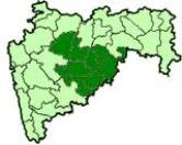
Desh
The region of Desh is having the borders with Sahyadri or Western Ghats in the west, Khandesh in the north, Marathwada in the east and southern part is covered by Karnataka state. This particular region has hilly landscape and has an eastern slope, with drainage by rivers Krishna and Godavari along with their branches.
When the context of the state of Maharashtra is taken into consideration, the Desh term has been derived from Maharashtra-Desh and this region comprises of the part of Deccan Plateau towards the west central region and the historical areas of Aurangabad or Pune and Marathwada.
Desale surname is one of the popular titles originating from this region. After passing away of Aurangzeb, when the Marathas extended their spread towards the north, some of the people from the region of Desh also shifted northwards. Due to this region, those with the surname Bhosale changed it to Desale as they left their Desh and hence, many of such surnames are found in the Khandesh region in North Maharashtra.
Khandesh
Khandesh forms a region of Maharashtra, located towards the central India, taking up a major part of northwestern region of the state. This region became the boundary to separate Maharashtra from Deccan.
Khandesh region comprises the areas of Dhule, Jalgaon and the Nandurbar districts in the state of Maharashtra.
Tapti River in this region is the remarkable natural feature. This specialty is that the Tapti starts from eastern part of Maharashtra and flows into the western side, which is quite different from other rivers of the Western Ghats, which have eastern flow into the Bay of Bengal. While passing through Khandesh, the River Tapti is joined by about 13 tributaries.
Farmers belonging to the Khandesh region are quite hardworking. Despite not having highly advanced facilities of irrigation, prior to the commissioning of the Hatnur and Girana dams, there was good produce, with the semi arid and arid region.
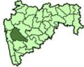
Konkan
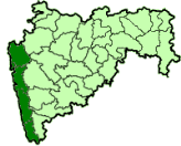
Karavali or the Konkan Coast is also simply called as Konkan and is marked by the coastline in the west, with plenty of rugged regions, extending from district of Thane to that of Mangalore. Mention of this division of Konkan has been done in the Skanda Purana, which is believed to be the Parashurama Srishti. The division of Konkan is one of the subdivisions of administration in the state of Maharashtra, consisting of almost all the districts in the state, which are bound by the coastline of India.
This region comprises a major part of the western coast of the state, with two districts belonging to Mumbai, also included in this division.
Famous Tourist Attraction
Ahmednagar, Akola, Amravati, Aurangabad, Beed, Bhandara, Chandrapur, Gondia, Hingoli, Jalgoan, Jalna, Kolhapur, Latur, Mumbai, Nagpur, Nasik, Pune, Raigarh, Ratnagiri, Satara, Sindhudurg, Solapur
Beaches
Harnai-Murud, Velas, Ganapatipule, Shrivardhan, Bordi Dahanu, Diveagar, Guhagar, Velneshwar, Harihareshwar, Vengurla, Kihim, Tarkarli, Shiroda.
Caves
Ajanta, Karla, Bhaje & Bedse, Elephanta, Ellora, Kuda, Mangi Tungi, Pitalkhora
Forts
Pratapgard, Shivneri, Lohagad visapur, Rajmachi Fort, Daultabad (Devigiri), Janjira, Korlai, Narnala, Vijaydurg, Sindhudurg, Panhala, Suverndurg, Mahuli, Vasai, Gavilgad, Arnala, Sion, Talgad, Avchitgad, Ghosalgad, Hirakot, Birwadi, Chandragad, Balapur, Kolaba, Surgad, Chandrapur, Jaigad, Raigad.
Wildlife Sanctuaries
Bhimashankar, Radhanagari, Sagareshwar wildlife, Nagzira wildlife, Navengaon National Park, Tadoba Andhari Tiger, Chikhaldara, Melghat Tiger Reserve, Kaas, The Pench-The Pandit, Rehekuri Blackbug, Karnala Bird Sanctuary, Painganga wildlife, Tipeshwar wild life, Bhambavli Pushp Pathar
Heritage Places
Bhimashankar, Aga Khan Palace, Elephanta, Ellora, Markandi Temple, Kaas Pathar, Koppeshvara, Lonar crater, Mansar, Chhatrapati Shivaji Terminus
Dams, Lakes and Water Bodies
Lonavala Khandala, Radhanagri, Bhandardara Dam, Koyana Dam, Malshej Waterfall, Dhamapur, Amboli Waterfall, Ghodazari Lake, Bhambavli Vajrai
Hot water springs
Vajreshwari, Akloli Kund, Ganeshpuri, Nimboli, Banganga, Nandi Gaygotha, Pimplas, Vada, Sativali, Shahapur, Unhere, Pali, Unhavare, Dapoli, Unhala, Rajapur, Unkeshwar
Hillstations
Mahabaleshwar, Panchgani, Matheran, Mhaismal, Bhimashankar, Lonevala Khandala, Tamhini Ghat, Wai, Panhala, Gagan Bavda, Malshej Ghat, Amboli Hill station, Toranmal, Bhandardara, Chikhaldara
You can follow us on LinkedIn and for more updates related to UPSC IAS Preparation, Like our Facebook Page and subscribe our Diligent IAS Youtube Channel