Indian Ocean is spawning strong 15/05/2019 – Posted in: Blog – Tags: cyclone, El Nino, Eline, fani, Idai, Indian Ocean Dipole, Kenneth, Saffir–Simpson scale, typhoon, warm sea surface
WHY THE INDIAN OCEAN IS SPAWNING STRONG
For: Preliminary & Mains
Topics covered: Cyclones (Fani, Idai, Eline, Kenneth), Causes
News Flash
The Indian Ocean has made its mark on the global news cycle this year. In March, tropical cyclone Idai made headlines as one of the most severe storms to have made landfall in Mozambique.
After Idai, Eline was the strongest — though not the deadliest — cyclone to have hit the southern east African cost. This ranking as the strongest was soon after challenged by tropical cyclone Kenneth, a category 4 tropical cyclone that made landfall over the border of Mozambique and Tanzania.
Most cyclones in Mozambique region occur from January to March. Kenneth, occurred very late in the season. It was also unusual for the Mozambique Channel to experience two severe tropical cyclones that made landfall within one season.
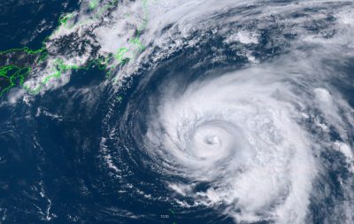
The third major cyclone to emerge out of the Indian Ocean came a few weeks after Kenneth, when cyclone Fani, a tropical cyclone on the border of Category 5 intensity wind speeds, hit the east coast of India.
Category 5 tropical cyclones were only first recorded in the North Indian Ocean from 1989 so, again, this storm is unusually severe in the context of the longer historical records.
Reasons Why Idai caused
- Lower-lying, relatively flat areas are more prone to flooding than higher elevation regions or those with rugged topography.
- Some regions will have better suited storm water infrastructure.
- And when flooding does occur, some regions are better able to warn and evacuate people to prevent or minimise the loss of life.
- This also means more people who would need to be evacuated in a short period, and more people who need shelter until the storm’s immediate effects have subsided.
This is why Idai and Eline resulted in far greater losses and fatalities than the stronger intensity Kenneth, and why the total damage from Fani is projected to be particularly devastating.
Reasons for high-intensity storms
- Warm sea surface.
High intensity storms have been tied to the very warm sea surface temperatures in the Indian Ocean. Temperatures of 30°C are occurring more often and over longer periods of time. This is a result of gradual warming on a global scale, which has resulted in a net increase in ocean temperatures.
- Warm ocean temperature.
Warmer ocean temperatures allow stronger storms to form. These conditions are exacerbated by global forcing mechanisms including El Niño and the Indian Ocean Dipole, which concentrates warm ocean waters in smaller geographic areas.
High intensity storms have been a frequent feature along the coast of the US throughout recorded history. Their increased frequency in the Indian Ocean should be raising alarm bells because countries like the US are much better equipped to help people prepare ahead of time, and to handle the fallout.
Measuring intensity
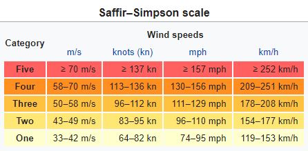
Tropical cyclone intensity is classified according to the Saffir Simpson scale.
- Categories are measured on the basis of the sustained wind speed and the storm’s central pressure. Each category is accompanied by estimates of the likely severity of damage and possible storm surge height.
Tropical cyclones form and intensify due to a combination of seven primary climatological conditions. Among other things, these include warm sea surface temperatures, high humidity levels and atmospheric instability.
For a storm to intensify, these conditions have to be maximised while the storm remains over the ocean.
| Ranking storms on the basis of their Saffir Simpson classification is not always the most valuable measure. That’s because it can’t take the characteristics of the location of landfall into consideration.
This results in two key shortcomings:
|
Required conditions for cyclones
- South Africa
Tropical cyclones require a sea surface temperature of 26.5°C to form, while the highest intensity storms require much warmer sea surface temperatures of 28-29°C.
This is important because it’s one of the reasons why southern Africa is experiencing more intense tropical cyclones.
- South Indian Ocean
The South Indian Ocean is warming rapidly. This means that regions that previously experienced the temperatures of 26.5°C that facilitated tropical cyclone formation are now experiencing temperatures as warm as 30-32°C.
- Equitorial regions
Regions further from the equator which didn’t previously have sufficiently warm water for tropical cyclone formation, with sea surface temperatures of 24-26°C are more regularly experiencing the threshold temperature. This increases the range in which these storms occur, making storms like tropical cyclone Dineo, which made landfall in February 2017 in southern Mozambique, more common.
Another Factors that generates cyclones
Very warm sea surface temperatures are not a factor of global scale warming alone. They’re further influenced by a range of global and local forcing mechanisms.
- These include El Niño Southern Oscillation, the Indian Ocean Dipole and the Southern Annular Mode.
- For this particular cyclone season, scientists are seeing the strongest impact from the [Madden-Julian Oscillation].
Madden-Julian Oscillation
This is a band of moisture in the tropical regions which moves eastward over a 30 to 90 day period. The strong Madden-Julian Oscillation is also affecting tropical cyclones in Australia.
Source: Down To Earth
You can follow us on LinkedIn and for more updates related to UPSC IAS Preparation, Like our Facebook Page and subscribe our Diligent IAS Youtube Channel
Also Read Related Daily News


