Indian version of Global Positioning System, NaVIC 03/01/2020 – Posted in: Daily News – Tags: Global Positioning System, IRNSS
NaVIC
For: Preliminary & Mains
Topics covered:
- About NaVIC
- About GPS – types and uses
News Flash
The ISRO and Chinese manufacturer ‘Xiaomi’ talks on the provision of chipsets that can support NavIC, the Indian version of the Global Positioning System (GPS). NavIC is the abbreviation of the Indian Regional Navigation Satellite System (IRNSS).
The Chinese smartphone maker is likely to use the NavIC-friendly chipset that is being manufactured by the US chip manufacturer Qualcomm.
Implications
- The implications of NavIC acceptance by 3GPP would bring NavIC technology to the commercial market for its use in 4G, 5G and Internet of Things (IoT).
- Manufacturers can now mass-produce navigation devices compatible with NaVIC so that users of these devices can easily access desi GPS and NaVIC signals.
Key Points
- The NavIC-friendly chipset is designed to provide accurate position information service to users in India as well as the region extending up to 1500 km from its boundary.
- Qualcomm has announced that its chip is going to have NavIC and now Xiaomi is in agreement to have it.
- Xiaomi may launch its mobile phones with NavIC chipsets.
IRNSS
- According to the ISRO, the IRNSS was developed for terrestrial, aerial and marine navigation, disaster management, vehicle tracking and fleet management and integration with mobile phones.
- It would provide Standard Positioning Service (SPS) to all users and Restricted Service (RS), which is an encrypted service for only authorised users.
- The IRNSS is expected to provide a position accuracy of better than 20 metre in the primary service area.
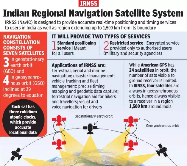
IRNSS Image: Times Of India
Global Positioning System
- The GPS, originally NAVSTAR GPS, is a satellite-based radionavigation system owned by the United States government and operated by the United States Air Force.
- It is a global navigation satellite system (GNSS) that provides geolocation and time information to a GPS receiver anywhere on or near the Earth.
- The GPS does not require the user to transmit any data, and it operates independently of any telephonic or internet reception.
- GPS supplies two different service levels, Standard Positioning Service and the Precise Positioning Service.
Standard Positioning Service
- The Standard Positioning Service (SPS), is a positioning and timing service provided on GPS L1 frequency and available to all GPS users.
- The L1 frequency contains a coarse acquisition (C/A) code and a navigation data message.
Precise Positioning Service
- The Precise Positioning Service (PPS), is a highly accurate military positioning, velocity and timing service broadcasted at the GPS L1 and L2 frequencies.
- Both frequencies contain a precision (P/Y) code ranging signal with an encrypted navigation data message that is reserved for authorized users.
Source: ET
READ MORE DAILY NEWS
- The Citizenship (Amendment) Bill, 2019
- Insolvency and Bankruptcy Code (Second Amendment) Bill, 2019
- The Recycling of Ships Bill, 2019
- The Arms (Amendment) Bill, 2019
- The Constitution (126th) Amendment Bill, 2019
- The Code on Social Security, 2019
- ISRO launched RISAT-2BR1
You are on the Best Online IAS preparation platform. You are learning under experts.
We are present on Facebook- Diligent IAS, LinkedIn- Diligent IAS, YouTube- Diligent IAS, Instagram- Diligent IAS. Get in touch with us.