Installation of Sensors for Monitoring Flood Situations 22/04/2019 – Posted in: Daily News
Installation of Sensors for Monitoring Flood Situations
For: Preliminary
News Flash
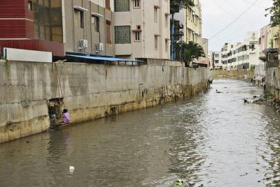
The Karnataka State Natural Disaster Monitoring Cell (KSNDMC) is all set to install telemetric flow gauges in 25 flood-prone stormwater drains (SWDs).
Telemetric flow gauges are sensors installed along the retention walls of SWDs.
Background
The project was taken up after the floods of July 2016 when Hulimavu and Madiwala lakes overflowed.
How it will work?
The devices will capture water levels in real time and send updates to a server every 15 minutes. In times of heavy rain, they can be adjusted to send an alert every minute. Officials will be able to access the information on an app.
Drain stretches are being categorised into red, orange and green zones based on their potential for overflowing and flooding.
| Karnataka State Natural Disaster Monitoring Centre
KSNDMC is a common platform for various response players in the area of natural disaster management. The centre provides real-time weather related information, forecasts, early warning and advisories for management of natural disasters in the state. In order to ensure high response times during natural disasters and proactively prepare its customers for them, KSNDMC needed to automate its weather data collection methods and use database technology that supported quick analysis and generated reports and maps on time. Esri India developed an internal and external GIS portal for KSNDMC which helped it perform data analysis, data visualization and data retrieval.
ArcGIS ArcGIS is a geographic information system (GIS) for working with maps and geographic information. It is used for creating and using maps, compiling geographic data, analyzing mapped information, sharing and discovering geographic information, using maps and geographic information in a range of applications, and managing geographic information in a database. |
Other Measures
- The KSNDMC envisages restoring interconnection between lake systems and flood-gates to manipulate water levels. Such a measure can help increase the water holding capacity of the city and mitigate flooding to a large extent.
- They are also recommended to digging up recharge wells to ensure we use flood water as a resource to recharge the underground water table.
Source: The Hindu