Latitudes and Longitudes 31/05/2019 – Posted in: NCERT
LATITUDES AND LONGITUDES
| TERMS YOU MUST KNOW
Latitude: Angular distance of a place from the equator. Longitude: Angular distance of a place from the Prime Meridian. Local Time: The time reckoned by the noon sun at a given place. Standard Time: The local time of the standard meridian of a country. Axis: An imaginary straight line joining the two poles on which the earth rotates. Poles: The two points on the earth through which the imaginary axis passes. Parallels of Latitude: Imaginary circles running parallel to the equator. Meridian of Longitude: Imaginary semicircles running from pole to pole. |
As we known, the earth is a sphere and has no edges from which one can measure distance. It has however, two fixed points the North Pole and the South Pole which serve as basic points of reference.
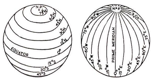
One set of lines are drawn in between the two poles in an east west direction. These are Parallel to the equator. That is why, they are called Parallels of Latitude. The other set of lines are drawn joining the North and the South Poles. They are semi circles. They are called Meridians of Longitude.
Latitude & Longitude
Latitude
We are aware that the axis of the earth which joins the North Pole and the South Pole is an imaginary line. Another imaginary line is the Equator which is drawn in such a way that at all points it lies exactly halfway between the North Pole and the South Pole. It thus divides the earth into two equal parts, i.e the Northern and the Southern Hemispheres.
Latitude is a measure of the angular distance of a given point from the equator. It is measured in degrees from the equator toward either pole. One degree is divided into sixty equal parts and each unit is called a minute. A minute is further divided into sixty equal parts and each unit is called a second.
The equator represents the zero degree latitude. Since the distance from the equator to either of the poles is one-fourth of a circle round the earth it will measure ¼ of 360 degrees, i.e.,90 degrees. Thus 90 degrees north latitude marks the north pole and 90 degrees south latitude marks the south pole.
As such, all points north of the equator are called north latitudes. Similarly all points south of the equator are called ‘south latitudes’
Important Parallels of Latitude
The equator is the largest, possible circle which can be draw around the earth. There are some other important parallels of latitude which have been given special names.
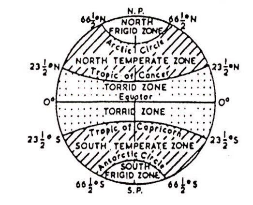
The Tropic of cancer is an important parallel of latitude in the northern Hemisphere. It is at an angular distance of 23.5 degree (23 degree 30’N) from the equator.
The Tropic of Cancer runs in an east west direction almost midway through our country.
The Tropic of Capricorn (23 degree 30’S) is another parallel similar to the Tropic of Cancer but is in the Southern Hemisphere.
The Arctic Circle lies at a distance of 66.5 degree (66 degree 30’N) north of the equator.
The Antarctic Circle (66 degree 30’S) is similar to the Arctic Circle but lies in the Southern Hemisphere.
Parallels and Heat Zones
Heat Zones of the Earth
The midday sun is exactly overhead at least once a year on all latitudes in between the Tropic of Cancer and the Tropic of Capricorn. This area, therefore, receives the maximum heat and is called the Torrid Zone.
The midday sun never shines overhead on any latitude beyond the Tropic of Cancer and the Topic of Capricorn. The angle of the sun’s rays goes on decreasing towards the poles. Beyond the Arctic and the Antarctic Circles, the sun does not raise much above the horizon. As such the areas bounded by the Tropic of Cancer and the Arctic circle in the Northern Hemisphere, and the Antarctic Circle in the Southern Hemisphere, have moderate temperature. These are, therefore, called Temperate Zones.
Areas lying between the Arctic Circle and the North Pole in the Northern Hemisphere and the Antarctic Circle and the south pole in the southern Hemisphere, are very cold. It is because the sun does not rise much above the horizon. Therefore its rays are always very slanting. These are, therefore, called Fridge Zones.
Longitude
To fix the position of a place, it is necessary to know something more than the latitude of that place.
For example, that Hyderabad (in Pakistan) and Allahabad (in India) are situated on the same latitude (i.e., 25 degree 25’N) . Now, in order to locate them precisely we must find out how far east or west these places are from a given line of reference running from the North pole to the South pole. These lines of reference are called meridians of longitude, and the distance between them are measured in degree of longitude. Each degree is further divide into minutes and seconds. They are semi-circles and the distance between them decreases steadily polewards, until it becomes zero at the poles, where all the meridians meet.
Unlike parallels of latitude, all meridians are of equal length. Thus, it was difficult to number the meridians. Hence all countries decided that the count should begin from the meridian which passed through Greenwich, where the British Royal Observatory was located. This meridian was called the Prime Meridian. Its value is 0 degree longitude and from it was count 180 degree eastward as well as 180 degree westward. Therefore the longitude of a place is followed by the letter E or W. Thus, if we have to state the longitude of Jabalpur which is situated 80 degree east of Greenwich, we shall say that its longitude is 80 degree E. It is, however, interesting to note that 180 degree East and 180 degree West meridians are the same line.
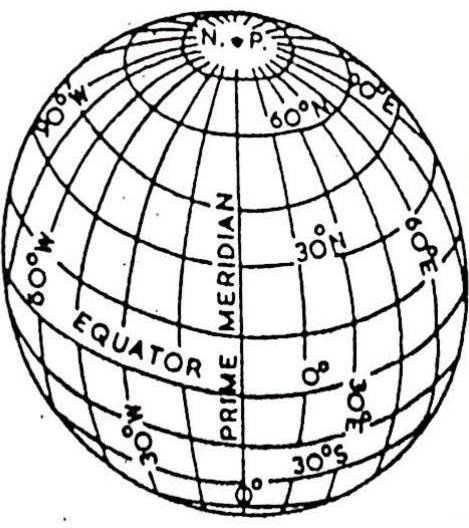
Grids of Parallel and Meridian
Longitude and Time
The best means of measuring time is by the movement of the earth, the moon and the planets. The sun regularly rises and sets every day and naturally it is the best time-keeper throughout the world. ‘Local’ time can be reckoned by the shadow cast by the sun, which is shortest at noon and longest at sunrise and sunset.
When the Prime Meridian of Greenwich has the sun at the highest point in the sky, all the places along this meridian will have midday or noon.
As the earth rotates from west to east, those places east of Greenwich will be ahead of Greenwich Time and those to the west will be behind it.
The rate of difference can be calculated as follows. The earth rotates 360 degree in about 24 hours, which means 15 degree an hour or 1 degree in four minutes. Thus, when it is 12 noon at Greenwich, the time at 15 degree east of Greenwich will be 15 x 4 = 60 minutes, i.e., 1 hour ahead of Greenwich time which means 1 p.m. But at 15 degree west of Greenwich, the time will be behind Greenwich time by one hour, i.e., it will be 11.00 a.m. Similarly, at 180 degree it will be midnight when it is 12 noon at Greenwich.
At any place a watch can be adjusted to read 12 o’clock when the sun is at the highest point in the sky, i.e., when it is midday. The time shown by such a watch will give the local time for that place.
Standard Time
The local time of places which are on different meridians are bound to differ. This will create problems for the people.
For example, it will be difficult to prepare a time table for trains which cross several longitudes. In India, for instance, there will be a diffirence of about 1 hour and 45 minutes in the local times of Dwarka in Gujarat and Dibrugarh in Assam. It is, therefore, necessary to adopt the local time of some central meridian of a country as the standard time for the country. In India, the longitude of 82.5 degree E (82degree 30’E) is treated as the standard meridian. The local time at this meridian is taken as the standard time for the whole country. It is known as the Indian Standard Time (IST).
Some countries have a great longitudinal extent and so they have adopted more than one standard time. For example, in Russia there are as many as eleven standard times. The earth has been divided in to twenty four time zones of one hour each. Each zone thus coves 15 degree of longitudes.
Source: NCERT
You can follow us on LinkedIn and for more updates related to UPSC IAS Preparation, Like our Facebook Page and subscribe our Diligent IAS Youtube Channel