Meghalaya – State’s facts and information 27/05/2019 – Posted in: STATE SERIES – Tags: Arunachal Pradesh, Assam, Manipur
MEGHALAYA
Meghalaya was formed by carving out two districts from the state of Assam: the United Khasi Hills and Jaintia Hills, and the Garo Hills.
The State of Meghalaya is situated on the north east of India. Tucked away in the hills of eastern sub-Himalayas is Meghalaya, one of the most beautiful State in the country.
It extends for about 300 kilometres in length and about 100 kilometres in breadth.
Shillong, the capital of Meghalaya is located at an altitude of 1496 metres above sea level.
Shillong, which was made Assam’s capital in 1874, remained so till January 1972, following the formation of Meghalaya. The capital city derives its name from the manifestation of the creator called Shyllong.
| Capital | Shillong |
| Date of Formation |
|
| State Boundaries | Assam |
| International Boundary | Bangladesh |
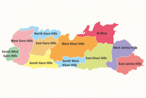
| Number of Districts | 11 |
| State Animal | Clouded Leopard |
| State Bird | Hill Myna |
| State Flower | Lady Slipper Orchid |
| State Tree | Gamhar |
| Language | Khasi, Pnar, Garo & English |
| Food crop | Rice, Maize |
| Horticultural crops | Orange, Lemon, Pineapple, Guava, Banana, Jack Fruits and temperate fruits such as Plum, Pear, Peach etc. |
| Cash crop | Potato, Ginger, Turmeric, Black Pepper, Areca nut, Tezpatta, Betelvine, Short-staple cotton, Jute, Mesta, Mustard and Rapseed etc. |
| Non-traditional crops | Tea, Cashewnut, Oilseeds, Tomato, Mushroom, Wheat etc. |
| Minerals | Coal, Limestone, Granite, Clay (China clay, white clay, fire clay), gypsum, phosphorite, glass-sand, base metals, quartz and feldspar. |
| Festivals of Khasis | Ka Shad Suk Mynsiem, Ka Pom-Blang Nongkrem, Ka-Shad Shyngwiang-Thangiap, Ka-Shad-Kynjoh Khaskain, Ka Bam Khana Shnong, Umsan Nongkharai, Shad Beh Sier |
| Festivals of Jaintias | Behdienkhlam, Laho Dance, Sowing Ritual Ceremony |
| Festivals of Garos | Den Bilsia, Wangala, Rongchu gala, Mi Amua, Mangona, Grengdik BaA, Jamang Sia, Ja Megapa, Sa Sat Ra Chaka, Ajeaor Ahaoea, Dore Rata Dance, Chambil Mesara, Do’KruSua, Saram Cha’A, A Se Mania or Tata. |
| Rivers | Ganol, Daring, Sanda, Bandra, Bugai, Dareng, Simsang, Nitai, Bhupai, Khri, Digaru, Umiam, Kynshi (Jadukata), Mawpa, Umiam or Barapani, Umngot and Myntdu |
| Lakes | Ward Lake, Umiam Lake |
| Waterfalls | Kynrem Falls, Khoh Ramhah, Dainthlen Falls, Nohkalikai Falls, Nohsngithiang Falls, Elephant Falls, Spread Eagle Falls, Krang Suri, Rong’bang Falls |
| Biosphere Reserve | Norkek Biosphere Reserve |
| National Park | Balphakram National Park |
| Wildlife Sanctuaries | Nongkhyllem Wildlife Sanctuary, Siju Sanctuary, Baghmara Sanctuary |
| Mammal species | Elephants, bear, red pandas, civets, mongooses, weasels, rodents, gaur, wild buffalo, deer, wild boar. |
| Tribes | Khasis (largest group) followed by the Garos then the Jaintias.
Other: Hajongs, the Biates, the Koches and related Rajbongshis, the Boros, Dimasa, Kuki, Lakhar, Tiwa (Lalung), Karbi, Rabha and Nepali. |
Climate
The climate varies with altitude. The climate of Khasi and Jaintia Hills is uniquely pleasant and bracing. It is neither too warm in summer nor too cold in winter, but over the plains of Garo Hills, the climate is warm and humid, except in winter. The Meghalayan sky seldom remains free of clouds.
People & Culture
Meghalaya is the homeland mainly of the Khasis, the Jaintias and the Garos.
- The Garos inhabit western Meghalaya, the Khasis in central Meghalaya, and the Jaintias in eastern Meghalaya.
- The Khasi, Jaintia, Bhoi, War, collectively known as the Hynniewtrep people predominantly inhabit the districts East of Meghalaya, also known to be one of the earliest ethnic group of settlers in the Indian sub-continent, belonging to the Proto Austroloid Monkhmer race.
- The Garo Hills is predominantly inhabited by the Garos, belonging to the Bodo family of the Tibeto-Burman race, said to have migrated from Tibet. The Garos prefer to call themselves as Achiks and the land they inhabit, as the Achik-land.
Education
- The history of formal education in Meghalaya has been a recent one commencing with the formulation of a Khasi Alphabet in 1842 by Mr. Thomas Jones, a Welsh missionary.
- Similarly for the Garo Hills areas, a Garo Alphabet was evolved in 1902 by American missionaries using the Roman script.
- The first college in fact was established in Shillong only in 1924 by the Christian Brothers of Ireland.
- Meghalaya is perhaps the first state in the region to adopt a ‘communitisation’ model of education at the elementary levels.
Agriculture
- Meghalaya is basically an Agricultural State with about 80% of its total population depending entirely on Agriculture for their livelihood.
- Food grain production sector covers an area of over 60 per cent of the total crop area.
Religion
Meghalaya is one of three states in India to have a Christian majority.
About 75% of the population practices Christianity, with Presbyterians, Baptists and Catholics the more common denominations.
The religion of the people in Meghalaya is closely related to their ethnicity.
Conversion from indigenous to Christianity began in the 19th century under the British era. In 1830s, American Baptist Foreign Missionary Society had become active in Northeast to convert indigenous tribes to Christianity.
Art & Crafts
Endi silk is used to make colourful wraps and hawls; baskets known as khokd thugis are commonly woven; cone shaped bamboo rain shields known as knup are also popular.
Notable Facts
- Cherrapunji, one of the most popular tourist attractions in Northeast India, is located in Meghalaya and holds the world record for most rain in a calendar month
- Meghalaya’s turmeric, particularly the variety that is grown in Shangpung in the Jaintia Hills, is considered the best in the world and its curcumine content is as high as 7.5%.
- Meghalaya is one of the few states in the country with surplus power generation. Industrial units in Meghalaya have the unique privilege of uninterrupted power supply.
- Neolithic sites discovered so far are located in areas of high elevation such as in Khasi Hills, Garo Hills and neighboring states.
- Meghalaya is mountainous, the most rain-soaked state of India. The word Meghalaya means, “abode of the clouds”.
- The highest point in Meghalaya is Shillong Peak, which is a prominent IAF station in the Khasi Hills overlooking the city of Shillong.
- The highest point in the Garo Hills is Nokrek Peak with an altitude of 1515 m.
- The Meghalayan forests are considered to be among the richest botanical habitats of Asia.
- A small portion of the forest area in Meghalaya is under what are known as “sacred groves”. These are small pockets of an ancient forest that have been preserved by the communities for hundreds of years due to religious and cultural beliefs. These forests are reserved for religious rituals and generally remain protected from any exploitation.
- Baghmara Sanctuary, is the home of the insect-eating pitcher plant Nepenthes khasiana also called “Me’mang Koksi” in local language.
- Meghalaya is also famous for its large variety of orchids — nearly 325 of them.
- Of these, the largest variety is found in the Mawsmai, Mawmluh and Sohrarim forests in the Khasi hills.
- The limestone caves in Meghalaya such as the Siju Cave are home to some of the nation’s rarest bat species.
- The hoolock gibbon is found in all districts of Meghalaya.
- Shillong is known as the Scotland of East.
- Rat Hole mining is done in the state (Recently banned).
- Ri-Bhoi district is famous for its pineapples.
- Shillong is also the headquarters of the North Eastern Council (NEC)
- The practice of creating Living root bridges can be found in Meghalaya.
You can follow us on LinkedIn and for more updates related to UPSC IAS Preparation, Like our Facebook Page and subscribe our Diligent IAS Youtube Channel