The new political map of India recently released 11/11/2019 – Posted in: Daily News – Tags: Anglo-Nepalese War of 1814-16, India-China War of 1962., Kalapani Territory, Treaty of Sugauli
The new political map of India
For: Preliminary & Mains
Topics covered:
- New Political Map of India
- Kalapani Territory
- Treaty of Sugauli
News Flash
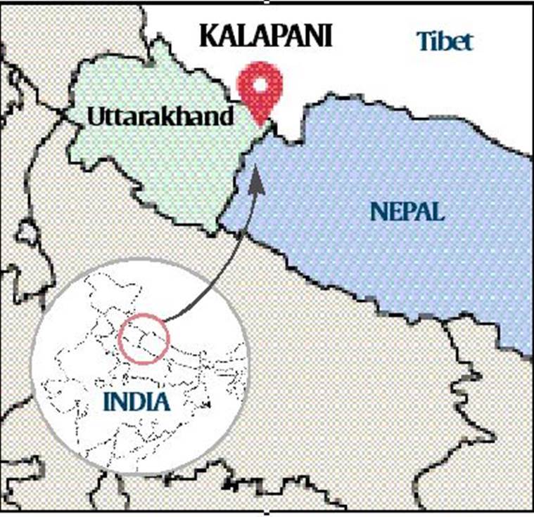
The new political map of India, recently released by the government to account for the bifurcation of Jammu and Kashmir, has triggered fresh protests over an old issue in Kathmandu, Nepal. The new political map of India shows Kalapani as part of India.
Kalapani territory
- It is a territory disputed between India and Nepal, but under Indian administration as part of the Pithoragarh district in the Uttarakhand state. The new political map of India shows Kalapani as part of India. The Kalapani, mapped within Uttarakhand is a 372-sq km area, bordering far-west Nepal and Tibet.
- Kalapani is is marked by the Kalapani river. The valley of the Kalapani forms the Indian route to Kailash–Manasarovar, an ancient pilgrimage site.
- Although claimed by Nepal as part of Darchula District, Kalapani is controlled by India’s Indo-Tibetan Border Police (ITBP) since the 1962 border war with China.
Boundaries
- The western boundary of Nepal with India was marked out in the Treaty of Sugauli between the East India Company and Nepal in 1816. Nepali authorities claim that people living in the low-density area were included in the Census of Nepal until 58 years ago.
- Nepal claims that the late King Mahendra had “handed over the territory to India” in the wake of India-China War of 1962.
- Earlier in a report by an committee formed by Nepal government, it claimed that India had “occupied” an additional 62 sq km land.
- The Prime Ministers of the two countries discussed the issue in 2000, with Atal Bihari Vajpayee assuring Nepal that India would not occupy even an inch of Nepal. Five years ago, the matter was referred to as a new mechanism comprising foreign secretaries of both sides.
Treaty of Sugauli
- It established the boundary line of Nepal, was signed on 2 December 1815 and ratified by 4 March 1816 between the East India Company and King of Nepal following the Anglo-Nepalese War of 1814-16.
- The treaty defines the Kali River as Nepal’s western boundary with India.
Important Information
Apart from Kalapani, another unresolved issue involves a vast area along the Nepal-Uttar Pradesh border. During his visit to Nepal in 2014, Prime Minister Modi had said that the Susta and Kalapani issues would be sorted out.
Source: Indian Express
READ MORE DAILY NEWS
- India’s maternal mortality ratio (MMR)
- National Programme for Organic Production (NPOP)
- Study “Climate Change and Heat-Induced Mortality in India”
- ‘India Internet 2019’ Report
- South Asia Co-operative Environment Programme (SACEP)
- Alternative Investment Fund
- Indian Air quality Interactive Repository (IndAIR)
You are on the Best Online IAS preparation platform. You are learning under experts.
We are present on Facebook- Diligent IAS, LinkedIn- Diligent IAS, YouTube- Diligent IAS, Instagram- Diligent IAS. Get in touch with us.